
Onondaga ZIP Directory Coverage
Research supports one primary documented postal ZIP for the Town of Onondaga: 13215. Town Hall, the assessor, clerk, codes office, museum, and court contacts use the Syracuse, NY 13215 postal convention. That is strong evidence of a Town postal practice, but it is not a promise that every Town address has the same delivery label. The county's map supplies only generalized context, and no official complete table of every ZIP intersecting the Town boundary was located.
| ZIP | Areas covered | Post office evidence | Research note |
|---|---|---|---|
| 13215 | Primary documented Town postal convention | Town contact addresses use Syracuse, NY 13215 | Verify each delivery address with USPS; postal city is not a Town boundary. |
| 13210 | Nearby Syracuse-area map context only | Appears in a parcel-card mailing-address example | No direct Town-wide coverage found. A mailing address does not locate the parcel. |
| 13214 | Nearby generalized-map context only | Shown on county ZIP map | No direct Town-of-Onondaga address coverage located. |
| 13224 | Nearby generalized-map context only | Shown on county ZIP map | No direct Town-of-Onondaga address coverage located. |
The directory therefore distinguishes documented Town practice from nearby map labels. It does not convert 13210, 13214, or 13224 into Town-wide coverage. A real edge case needs its own delivery result and parcel check.
Read Onondaga Postal Labels as Delivery Data
Syracuse is the postal city printed on many Town of Onondaga public-office addresses. The Town's legal municipality remains Town of Onondaga. Postal city, municipality, county, tax district, school district, fire district, and election district are separate geographies that may overlap without matching. A Syracuse postal label therefore does not establish City of Syracuse jurisdiction.
Town Hall is a useful local example because the assessor, clerk, Justice Court, Codes office, museum, and Historical Society access cluster at 5020 Ball Road with the Syracuse 13215 postal label. The same address can be confirmed through the Town's municipal information and through an address-level postal result, each for its own purpose. This geography issue is why a ZIP should not be used as the parcel key in property research.
Check an Onondaga Address With USPS
Use the USPS address lookup when the question is the delivery ZIP for one address. Enter the street number, street, city, and state as known, then preserve the returned delivery city and ZIP with the date of the search. USPS is the address-level verification route described in the research. It does not draw a municipal boundary or confirm a parcel's tax identity.
The USPS address lookup begins with a specific delivery address rather than a generalized boundary map.
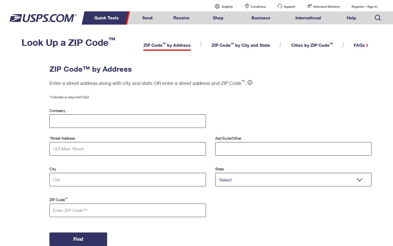
Use the result as delivery evidence for that address and date. For a Town question, compare it with the parcel's municipality, tax-map number, SWIS, and local assessment record. A return of Syracuse as the delivery city is not a change in Town jurisdiction.
Use the Onondaga County ZIP Map Carefully
The Onondaga County generalized ZIP boundary map, dated January 2026, depicts 13215 around the Town and southern Syracuse area and labels 13210, 13214, and 13224 nearby. Its own disclaimer says it is generalized and not an official Post Office document. It helps describe county context, but it cannot prove that a boundary street or parcel lies wholly in one delivery area.
Keep the map date and disclaimer with any result. A parcel can touch a road or district that uses another mailing label, and one delivery area can cross municipal lines. The map is most useful after a USPS check, where it can help explain nearby geography without replacing the delivery result.
Note: The county map is a visual reference for the region, while USPS supplies the stronger answer for an individual delivery address.
Use Onondaga ZIP Search Fields Carefully
A ZIP control can narrow a particular official portal, but it does not create a Town resident list. The New York voter lookup accepts County, Last Name, First Name, Date of Birth, ZIP Code, and address information, with required fields marked on the form. Its result is limited to an enrolled voter's registration, polling, or ballot information. It is designed for an individual search, not a bulk address or ZIP search.
| Voter lookup field | Documented use or format |
|---|---|
| County | Select the county, including Onondaga County for a Town query. |
| Last Name | Text field for an individual name search. |
| First Name | Text field used with the individual search. |
| Date of Birth | Use the MM/DD/YYYY format shown by the form. |
| ZIP Code | Text field that helps route an individual registration inquiry. |
| Address information | Required by the page instructions; exact live control labels were not captured in the research. |
The voter form requires cookies and JavaScript, and a no-result can reflect differences in a name, address, or list maintenance. The county Board of Elections handles local election administration and records questions at 315-435-8683. Public registration records remain subject to Election Law limits, including protection for driver-license, non-driver ID, Social Security, and facsimile information.
Find an Onondaga Address by ZIP
ZIP information works best as a narrow address check. It can help confirm a delivery label before an individual voter inquiry or before an address is compared with a parcel record. It cannot establish municipal residence or generate a list of people within a code. Once a result is narrowed to a road and number, use the street-level records process instead.
- Start with an exact number and street, then run the address through USPS to preserve the returned delivery city and ZIP.
- Check the parcel in Onondaga County GIS and record the municipality, tax-map identifier, and SWIS alongside the postal result.
- Use Image Mate by physical address or tax-map number to find the assessment record. Do not use ZIP as the parcel key.
- When an individual registration question remains, use the NYS voter lookup with its required identity and address information, and keep any result limited to what the form returns.
- For deed, permit, or street-history questions, preserve the address and parcel information and continue with the relevant custodian rather than treating the ZIP result as proof.
When a ZIP check has narrowed the question to one road, the Onondaga street directory provides the address-to-parcel and deed workflow.
Compare Onondaga Parcel and Mailing ZIPs
Assessment records distinguish a physical situs from the current owner mailing address. The official Cook Road sample uses a Thayer Street, Syracuse 13210 mailing address, while the parcel situs is in the Town of Onondaga. The Horseshoe Is Road sample has a Clay 13041 mailing line. Both examples show why a mailing ZIP describes correspondence and cannot be used to place the parcel or a person in that postal area.
Record the assessment field exactly as labeled. Pair it with the parcel's situs, tax-map ID, SWIS, roll year, and source date. This simple comparison is a local, documented safeguard against confusing an owner mailing line with municipal geography or physical location.
Verify Onondaga Municipal Geography
Boundary-edge research needs three separate checks: the USPS result for delivery, the county generalized map for regional context, and the GIS or assessment record for parcel and Town identity. Add an election, school, fire, or tax district only as a separate attribute. None of those layers should be used as a substitute for the Town municipal boundary.
If the three sources do not agree, retain the conflicting labels instead of forcing a match. The Town assessor is the local route for an assessment or roll question, while County GIS supplies the parcel-viewing context. Town assessor Michael Morrissey is listed at 315-469-3216 at Town Hall. For a map product or a historical parcel question, the county also makes tax maps available through RPTS and at the Civic Center; an address search can help find the tax-map number before a map is requested.
For an existing Town record about an address, describe the exact situs, tax-map ID, and date range to the department or in the Town Clerk FOIL request form. FOIL is a route to existing records, not a request to compile a ZIP-wide list. The form specifically recommends a property address or tax ID for parcel-related requests, which makes it a more precise fallback than a postal label alone.
County GIS can show tax parcels, districts, aerial imagery, flood information, and zoning context. Its parcel polygons were digitized from paper maps in 1995, updated through 2024, and migrated to ESRI in 2024. Condominiums may overlap in the data. For that reason, a visual point-in-polygon match should be checked against the 26-character Tax ID, tax map, and legal description when precision matters.
Boundary warning. A ZIP is delivery geography, not a municipal ruling. Keep nearby 13210, 13214, and 13224 labels separate until a specific address is verified.
Limits of the Onondaga ZIP Directory
The postal directory is an address-verification reference, not a comprehensive people list. No official complete Town ZIP-intersection table was located, and no verified postal realignment history specific to the Town was found. Postal, GIS, assessment, and election systems also update on different schedules, so a returned ZIP is evidence for that field and date, not a permanent claim.
- ZIP
- A delivery-area label used by the postal system. It is not a municipal boundary.
- ZIP+4
- An added delivery detail that narrows a standard ZIP for mail sorting. It does not change the Town boundary.
- PO-box ZIP
- A ZIP used for post-office-box delivery. Research did not establish a Town-specific PO-box ZIP.
- Unique ZIP
- A ZIP assigned to a single organization or place. Research did not establish one for the Town.
- Carrier route
- A postal delivery grouping. It is not a parcel, voter, or municipal-residence record.
For historical mismatches, search old street or route terms in dated directories, then validate the modern location through the deed's legal description, tax map, and assessor record. Keep the source, date, returned delivery city, municipality, and any unresolved boundary caveat together.